Natural disasters
have adverse effects on the earth and the general population. A
natural disaster has numerous negative results such as loss of lives
and property, economic damages and serious environmental damages.
Some of these natural disasters include earthquakes, volcanic
eruptions, hurricanes, floods, tsunami and other geologic processes.
Modern technology seeks to prevent and change the effects of these
disasters. The integration of new technology plays a role in disaster
prevention and management. Technological advancements have also
helped countries improve on their disaster preparation.
 |
| A Southern California GPS receiving station. |
Modern technology
assists in the rapid detection and identification of possible natural
disasters. Through detection, the natural disasters are easily
identified, and the areas to be affected are able to apply various
approach to reduce the effects of the disaster on population and
property. This allows for early disaster management. Modern Global
Positioning System (GPS) receivers are usually connected to video and
digital cameras to aid in the collection of data on buildings and
other elements that are at risk. Geographic coordinates are used to
link field information to the corresponding area of the satellite
image.
This supports the
analysis and classification of occurrence of natural disasters. GPS
speeds up the initial evaluation of earthquakes separate from
traditional measuring methods such as seismometers. It allows for the
estimation of magnitude and slip. The GPS approach records data from
previous earthquakes but not those that are in progress. Therefore,
the method can lead to earlier warnings of approaching earthquakes.
This helps to allow emergency personnel have a quick response towards
damaged zones. GPS also assists to determine where there is crust
movement and the area that is prone to the greatest damage.
Early disaster
identification also prevents the widespread impact of the disaster.
The primary element of reducing the opposite effects of a disaster is
preparation. After periods of disaster, governments and local
administration are tasked with bringing the state back to the initial
condition. This causes increased financial and labor constraints.
Therefore, technology that predicts disaster avoids such situational
and occupational hazards. For instance, after Hurricane Katrina, the
treatment of patients proved difficult because the medical doctors
were unaware of the victim’s medical history. In addition, 1800
people were killed by hurricane Katrina. However, hurricane Ike
killed close to 30 people because the government used technology to
warn and evacuate people ahead of time.
 |
| Hazard maps. |
Technological
advancements also help to establish suitable disaster warning systems
among the general population. GIS is an essential tool for the
efficient manipulation and storage of data that are remotely sensed.
In addition, it is used for spatial and non-spatial data for policy
oriented information and scientific management. This is used to
simplify the mapping, measurement, modeling and monitoring of various
data types that are related to natural phenomena. Hazard maps and
Threat maps are used to assess floods, landslides, earthquake and
other meteorological aspects. These data is provided to the general
population to warn of disasters such as drought, earthquake and
floods. This helps in the development of suitable warning systems
towards disaster preparedness. India has incorporated these
technologies in public disaster communication minimizing the overall
consequences of disasters.
Technological
innovation plays a role in understanding the vulnerability of
particular regions in relation to natural disasters. Vulnerability
refers to the physical and geographic characteristics of a zone that
make it likely to be affected by natural disasters. The study and
analysis of the level of vulnerability assists in the establishment
of programs for disaster preparation. For instance, regions that
experience high volcanic activity are likely to have earthquakes,
pyroclastic fall and tephra fall.
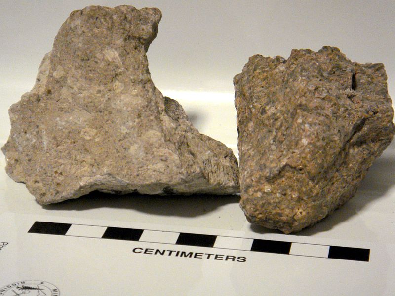 |
| Tephra is a result of volcanos on the materials. |
These countries include Tenerife,
Azores and Caribbean. Vulnerability is measured using various
technologies such as satellites, field equipment that uses GPS
technology and computer software. For instance, Philippines has high
vulnerability levels in storms, earthquakes and tropical cyclones.
With this knowledge, the state has improved on disaster preparation.
The modern
technology is used in the formulation of an early warning system for
natural disasters. This system incorporates elements of disaster
detection and prediction in order to culminate in a suitable disaster
warning system. The disasters are detected in terms of time, type,
speed, direction, magnitude and the expected physical area to be
affected. The early warnings are transmitted via a wide array of
microprocessor controllers/receiver that is embedded in consumer and
commercial devices that are used regularly. This creates a universal
standard for the reception of warnings. Therefore, there is an
effective and efficient disaster warning approach for users.
The technology
allows for spread of information to all mobile devices that have the
capability of receiving early signals that warn of impending
disaster. Direct early warnings are provided to particular receivers
that are at risk of danger and disaster. In addition, groups, which
pose great danger to natural disaster as determined by geographic
information and current location, are also given primary
consideration. This system minimizes unnecessary and false disaster
warnings. Therefore, the receiver has confidence in the need to
undertake the action to carry out effective and efficient reduction
action on the beginning of a natural disaster. Through this approach,
fewer deaths are recorded during disasters.
 |
| Saudi Arabia, Jeddah flood in 2011. |
New technologies
also allow better planning and policies natural disaster management.
The integration of technology helps governments and administration to
have proper planning methodologies towards containing disasters. In
addition, laws and policies are formulated from the technological
information collected from disasters. Floods occur in the global
scene to account for one-third of the total losses that result form
natural disasters. In 2010, floods were the most frequent natural
disaster affecting 178 million people. The countries that are mainly
affected by floods have held conferences and gathering to relieve the
effects of the disaster.
Some of these
policies include better service delivery to farmers and financing the
integration of forecasting technology and research. In efforts to
predict these disasters, scientists have turned their attention
towards open data that give evidence based analytical approaches.
Accordingly, mapping is undertaken for the purpose of planning and
showing the regions in which disasters might have the greatest
impact. These approaches are used by government departments in
disaster response to formulate suitable policies that will aid in
short term and long term methodologies, in disaster management. The
use of technology by government in planning and emergency response
has reduced the overall financial costs incurred during disaster
management. The Geo-Node platform has helped people in the Caribbean
to make better decisions and policies in relation to disaster
management.
 |
| Alert service to warn people for Tsunami. |
One of the major
difficulty during disasters is the response mechanism. Disaster
response programs have integrated technology in order to ensure
effectiveness. After disaster, communication, transport and other
areas of connection are usually disconnected or unreliable. However,
technology seeks to change these discrepancies and ensure that
disaster response is made easier and reaches out to all the affected
groups of people. Access to information is equally important to the
access to food and water for many of the victims. For instance,
mobile technologies assist affected populations during a disaster to
be identified. In addition, emergency teams are able to keep track of
the total number of deaths, victims and the total number of people
affected.
 |
| Port-au-prince earthquake in Haiti. |
Disaster affected
populations are steadily adopting mobile technologies for disaster
response. Through these technologies, the affected people are
extensively able to source, generate and share a big amount of
relevant information. This has led to significant transformations in
disaster response. Within 48 hours of the earthquake that had
stricken Port-au-prince in Haiti, in 2010, the aid emergency
organizations had already established a short SMS code to outsource
information. Through this technology, the overall needs of the
disaster hit population were met. In addition, the victims could be
tracked and the sick hospitalized.
Technological
advancements also provide critical information on the occurrence and
impact of natural disasters. This set of information is useful in the
determination and assessment of the impact of the disaster on the
social and economic development of the affected state. The technology
can be in the form of software suited towards disaster statistics and
the internet. This information is also used in the prediction of
future consequences of a similar disaster. Governments are therefore
able to establish proper planning methodologies in disaster
management. For instance, the mobile technology used in Haiti helped
to provide a live crisis map. This proved to be most up-to-date and
comprehensive information for the government and humanitarian groups.
Live crisis maps are crucial during disaster response as they are
essential in the provision of real time situational awareness and
information for future disaster response. The ultimate result is a
significant change in disaster management.
 |
| Hurricane Sandy in 2012. |
In conclusion,
modern technology is fundamental in the development of policies and
disaster management. In the past years, there have been numerous
disasters such as the Japanese earthquake, the Haiti earthquake,
Hurricane Katrina, floods across the globe and the recent Hurricane
Sandy in New York. It is necessary for research to integrate
technology to find the main cause of these disasters. Some disasters
have also been discovered to be caused indirectly be manmade
activities that cause climate change leading to natural disasters.
The comprehensive solution to effective disaster preparation and
management is technology.
Written by: Meshal Alawwad

No comments:
Post a Comment